


Warehouse layouts rarely remain unchanged. Racking may be relocated, temporary storage areas may become permanent, new safety barriers may be installed, and travel lanes may be redesigned. For a Chinese AGV using Laser SLAM navigation, the key question is not whether the warehouse can change, but how efficiently the navigation map can be updated without disrupting the entire fleet.
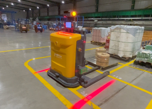
Moving warehouse racks does not necessarily mean that every Chinese Laser SLAM AGV must be completely remapped. If the navigation software supports local map editing or partial map updates, engineers can modify the affected area while keeping stable portions of the existing map. However, major structural changes that alter key reference features, travel corridors or large portions of the operating environment may require a new mapping process and validation.
Not necessarily. A Laser SLAM AGV continuously compares its laser-scanned environment with the navigation map to estimate its position. If the warehouse environment changes significantly, however, the vehicle may have difficulty matching the new environment with the old map.
Moving an entire rack aisle is more significant than simply moving one pallet rack or installing a temporary obstacle. The relocation can change the geometry of the navigation corridor and remove reference features that the vehicle previously used for localization.
Small Layout Change
A few movable objects or localized storage changes may not require a full remapping process.
Moderate Layout Change
A relocated rack section or changed travel lane may require local map editing and route validation.
Major Layout Change
Large structural changes can require broader remapping and a complete navigation test.
Do Not Test a Major Layout Change Directly During Production
When a complete aisle is relocated, validate the updated map in a controlled area before returning the full AGV fleet to normal operation.
Many modern fleet management systems can support some form of map editing, but the exact capability depends on the supplier's navigation software. The important distinction is between changing a logical route and changing the underlying SLAM map.
A route can often be modified without rebuilding the entire environment. For example, a restricted zone, temporary no-entry area or new travel path may be added to the operational configuration. A physical change to the environment may require an updated map segment or a new localization scan.
1
Identify Changed Area
2
Create Updated Scan
3
Align Map Segment
4
Validate Localization
5
Test AGV Routes
The exact procedure varies between Chinese AGV manufacturers. In general, the process starts by identifying the affected navigation area and determining whether the change can be handled through configuration or requires a new SLAM scan.
A practical engineering workflow is to isolate the affected zone, create the updated map information, align it with the existing coordinate system and then test the AGV's localization at the boundaries between the old and updated areas.
Back up the current production map.
Record the locations of racks, stations and navigation landmarks.
Identify which AGVs are affected by the change.
Check whether the supplier's software supports local map editing.
Define a safe testing window before publishing the updated map.
Laser SLAM sensors can detect physical objects that appear within their sensing field. However, detecting an obstacle and permanently updating the navigation map are two different functions.
A new pallet, temporary barrier or parked forklift may simply be treated as an obstacle to avoid. A newly installed rack, wall or permanent safety structure may require the navigation map and route configuration to be updated.
Temporary Obstacle
The AGV detects it and can normally plan around it according to the configured obstacle-handling logic.
Permanent Structure
The map or route configuration may need to be updated so that future navigation reflects the new environment.
Unexpected Change
The fleet system can generate an obstacle or navigation exception that requires operator review.
Potentially, depending on the fleet software. A mature fleet management platform can record navigation exceptions, obstacle events and repeated localization problems. Whether it automatically sends an alert to a manager depends on the software's alarm and notification functions.
Repeated Obstacle
The same area repeatedly causes the vehicle to stop or reroute.
Localization Exception
The vehicle cannot confidently determine its position.
Route Blockage
A planned path remains unavailable for an extended period.
Map Mismatch
The physical environment differs substantially from the navigation map.
There is no universal percentage that determines when a Chinese Laser SLAM AGV must be completely remapped. A simple percentage such as “20% of the warehouse” cannot reliably describe navigation difficulty.
What matters more is where the changes occur and whether they affect the AGV's localization references, major travel corridors, intersections, docking stations or other critical navigation areas.
Location Matters More Than Percentage
Changing a small but critical navigation corridor can have a greater impact than changing a much larger storage area that the AGV rarely traverses.
| Layout Change | Likely Map Requirement |
|---|---|
| Small temporary storage change | Usually obstacle handling or route configuration |
| One rack section relocated | Potential local map update and route validation |
| Entire aisle relocated | Significant map update and navigation validation |
| Major warehouse restructuring | Potential full remapping and system validation |
After relocating racks, do not only verify the new rack locations. The complete AGV route around the affected area should be checked.
Travel Aisles
Check clear width and the new navigation corridor.
Intersections
Verify that route priorities and turning paths remain valid.
Rack-End Turning Areas
Confirm that the AGV still has enough space to complete its maneuver.
Pickup Locations
Verify that the vehicle can approach the pallet station using the intended path.
Drop-Off Locations
Confirm that rack and pallet coordinates remain correctly aligned.
Safety Zones
Check pedestrian areas, restricted zones and emergency routes after the change.
The safest approach is to test the updated map progressively instead of immediately releasing every AGV into the modified area.
1
Backup Existing Map
2
Update Changed Area
3
Test Localization
4
Test Routes
5
Test Pickup & Drop-Off
6
Release Fleet
Does the fleet software support partial map updates?
Can my local engineering team edit restricted zones and routes without changing the SLAM map?
Can the original production map be backed up before an update?
How are map versions managed and restored?
Can multiple AGVs use the updated map simultaneously?
Does the system record localization failures caused by environmental changes?
Can the fleet platform alert operators when repeated obstacles appear in the same location?
What level of layout change does the manufacturer recommend for a complete remapping?
Warehouse automation should not depend on a layout that never changes. When evaluating Chinese Laser SLAM AGVs, ask how maps are backed up, edited, versioned and restored, and whether your local team can perform controlled map updates without relying on a complete fleet remapping every time warehouse racks move.
FREE ENGINEERING SUPPORT Stop Gambling on Generic Platforms. Get an AGV/AMR Tailored to Your Warehouse.Buying automated guided vehicles involves complex safety standards (CE/ANSI), navigation setups (Laser SLAM), and ERP system integration. Don't risk your factory safety with middle-men. ✓ 100% Direct Factory: Customized payload up to 5 Tons. ✓ Free CAD Simulation: Send us your layout, and our engineers will simulate the optimal AGV routes. ✓ Global Support: Overseas installation guidance & local maintenance partners. |





 Chinese
 English